Register for UIC GIS Day 2019
Register for UIC GIS Day 2019: Poster submission deadline is November 15!
Join the Urban Data Visualization Lab (UDVL) and the University Library on Friday, November 22nd, 2019, from 10:00 am – 3:00 pm to celebrate GIS Day 2019 at the Richard J. Daley Library (1-470). This event is open to the public, and made possible through the generous support of the Sööt Family Fund.
GIS (Geographic Information Systems) and visualization techniques allow us to organize, analyze, and communicate data. This year, GIS Day will showcase a range of techniques exploring different aspects of Community and Global Disparities. UIC GIS Day 2019 will include a keynote speaker, talks, a panel, a poster session and competition, and a hands on-workshop. Poster winners will be awarded an individual ArcGIS Personal Use license, and free GIS training from UrbanGIS! Submit your poster abstracts by November 15, 2019.
GIS Day at UIC brings an opportunity to learn about innovative techniques and impactful applications, and network with others interested in or working on a range of visualization approaches to classwork, research or professional activities.
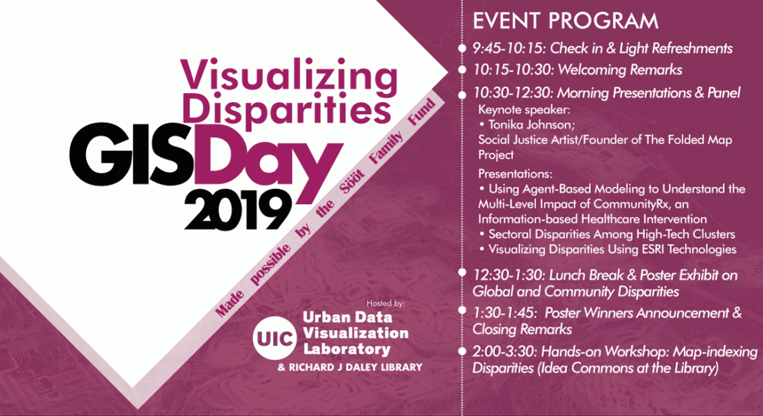
EVENT PROGRAM
9:45-10:15: Light Refreshments & Check-in
10:15-10:30: Welcoming Remarks
10:30-12:30: Morning Presentations and Panel
Keynote speaker:
Tonika Johnson; Chicago based Social Justice Artist & Founder of The Folded Map Project
The Folded Map Project visually connects residents who live at corresponding addresses on the North and South Sides of Chicago, as Tonika investigates what urban segregation looks like and how it impacts Chicago residents. The Folded Map
Project includes photographic studies, multimedia exploration with video interviews, and geospatial data analysis and visualization.
Presenters (*) and Panelists:
• Jonathan Ozik*; Senior Scientist in the Consortium for Advanced Science and Engineering, University of Chicago: "Using Agent-Based Modeling to Understand the Multi-Level Impact of CommunityRx, an Information-based Healthcare Intervention "
• Ahoura Zandiatashbar*; Geospatial Data Scientist, Urban Data Visualization Lab, University of Illinois at Chicago: "Sectoral Disparities Among High-Tech Clusters"
• Yolanda Richards*; Economic Development Professional, ESRI: "Visualizing Disparities Using ESRI Technologies"
• Ivan Arenas; Associate Director for Community Partnerships, Institute for Research on Race and Public Policy, University of Illinois at Chicago
• Marisa Bryce; Co-Founder and President, CityXones
12:30-1:30: Lunch Break & Poster Exhibit on Global and Community Disparities
1:30-1:45: Poster Winners Announcement & Closing Remarks
2:00-3:30: Hands-on Workshop: Map-indexing Disparities (Idea Commons at the Library)
Hands-on practice of a joint statistical analysis & spatial visualization procedure to simplify and reduce high-dimensional socio-economic data to compute and visualize one disparity index for Chicago’s neighborhoods.
Registration:
Student Fee: $5.00
General Population: $10.00
Registration fee is waived for accepted posters. Submit an abstract for poster presentation first to get your fee waiver code.
Submit Abstract for Poster Presentation Here
Poster Presentation Templates
Register for GIS Day 2019 Here
If you have any questions, please contact udvl@uic.edu, visit our website or stay connected with us on our twitter page.
Thank you in advance on behalf of UDVL for making GIS Day 2019 a success!