Final Projects Showcase
GIS classes - Final Projects Showcase
Chicago's Community Fridges
Authors: Gwen McCain, Cassie Varrige, and Addie Wasikonis
Course: UPP 461, Fall 2023
This project was centered around combating food insecurity in Chicago by implementing community fridges, which served as essential hubs for providing free access to food for individuals and families facing hunger. Completed through meticulous research, the initiative identified and verified existing fridge locations while conducting extensive qualitative analysis to determine success factors. Utilizing GIS technology, a suitability index was developed to identify potential locations for future installations based on need, access, and community support. Spearheaded by organizations like Love Fridge and Veggie Mijas, these community-driven initiatives fostered food justice and accessibility, particularly in marginalized communities. Despite acknowledging challenges such as the decentralized nature of mutual aid networks and the influence of non-geospatial factors on fridge success, the project offered valuable insights and resources for grassroots organizations seeking to expand their impact in combating hunger and promoting community resilience. Future collaborative efforts and continued data-driven analysis could empower communities in their fight against food insecurity and inequity.
Community Gardens and Violent Crime in Chicago
Authors: Marjorie Kersten, Ezra Wright, Nicolas Tantely Raoilmanantsoa
Course: UPP 461, Fall 2023
This project delved into the persistent issue of violent crime in the United States despite a significant decline over the past few decades, juxtaposing it with markedly higher rates compared to other high-income countries. This disparity underscored the urgency of addressing violent crime, particularly in marginalized communities where it disproportionately affected non-white and low-income individuals, contributing to various adverse health outcomes. To mitigate these effects, the project explored interventions such as increasing access to maintained green spaces, yet the impact of community gardens on crime in Chicago remained understudied. Utilizing ArcGIS Pro, the study investigated the relationship between establishing community gardens between 2010 and 2016 and their potential influence on violent crime in Chicago. The methodology involved mapping garden locations within neighborhoods exhibiting higher poverty and unemployment rates and social vulnerability indices alongside crime data from two years before and one year after each garden’s establishment. While the analysis provided new insights into this relationship, challenges, including data cleaning complexities and limitations in crime data availability, underscored the need for cautious interpretation and suggested avenues for future research to delve deeper into statistical analyses and refine garden selection criteria.
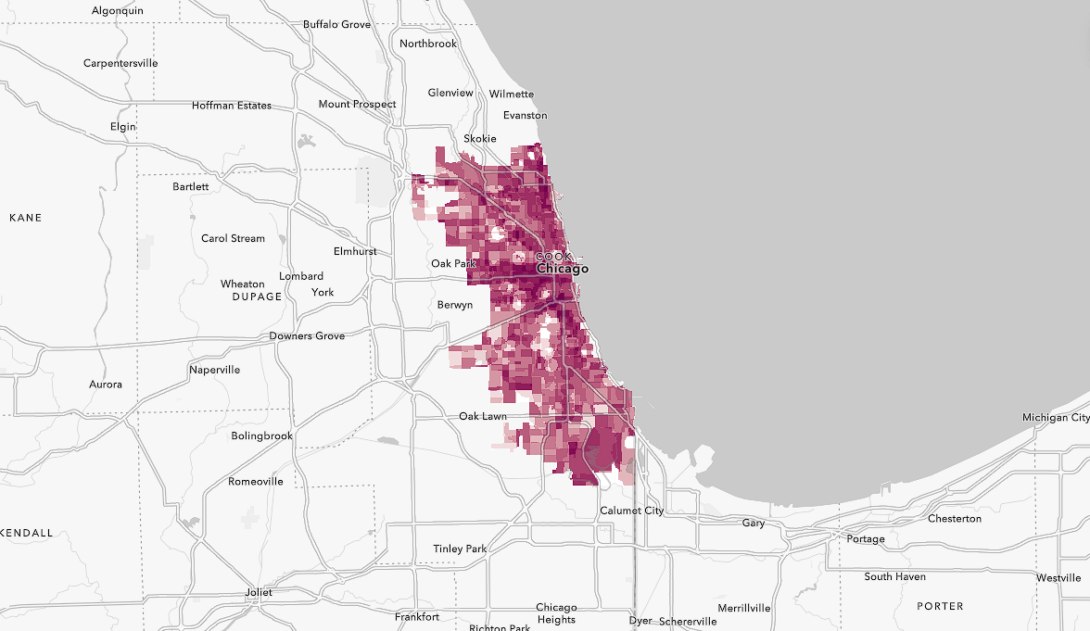
Mapping Vulnerability to Lead Water Exposure
Authors: Sebastián Villa-Rodriguez
Course: UPP 462, Spring 2023
This project visualizes census tracts with the highest risk of lead exposure from lead service lines in Chicago. Although the federal government prohibited lead-based paint in 1973, lead service lines in new housing construction were not banned in Chicago until 1986. Historically, prior Chicago mayors have not addressed this problem and today there are an estimated 400,000 service lines, the most of any U.S. city. This study develops a vulnerability index to measure risk of lead exposure in households’ water supply based on sociodemographic and housing data (Median Household Income, Residences Built Pre-1980, Single Family or Two Flat Residences, Population without Health Insurance, People of Color (Black and/or Latinx), Presence of Children).
Analyzing Potential Areas For Divvy Expansion
Authors: Sean O’Rourke
Course: UPP 462, Spring 2023
Divvy is Chicago’s bike share system which has been around since 2013. It is run by the Chicago Department of Transportation (CDOT) but was sold to Lyft in 2018. Today, it serves people through over 829 stations from all around the city. Many areas of the city still lack Divvy service and there are existing holes within the network. In order to be a truly equitable service, Divvy needs to serve everyone across the city. The goal of this project is to identify different areas where Divvy could expand its service as well as identify different holes within the existing network of stations. GIS offers advanced tools that could be used to identify gaps within the Divvy network and determine good locations for potential expansion. This is a spatial problem and looking at it spatially helps reveal trends that might not be picked up.