UPP 461 | Spring 2022
Final Project Showcase
In Spring 2022, this section of the UPP461 class produced 10 team and individual projects on a variety of topics. Teams have several weeks in the second half of the semester to develop research questions, investigate the topic of their interest, explore GIS tools to address their questions and produce the final visuals. Students were encouraged to use multiple analytical techniques/tools covered in the course (e.g., geoprocessing tools such as buffer, clip, and intersect, geocoding, work with rasters, table and spatial joins, etc.), as well as good use of symbology, labeling, color selection, map projection, and layout design. The final result includes an ArcGIS StoryMap report where maps and additional information are used to illustrate methods and communicate findings. Thanks to all the students for your hard work during the semester.
Instructor - Anton Rozhkov
1. Gaps in Affordable Housing provision in Chicago Heading link
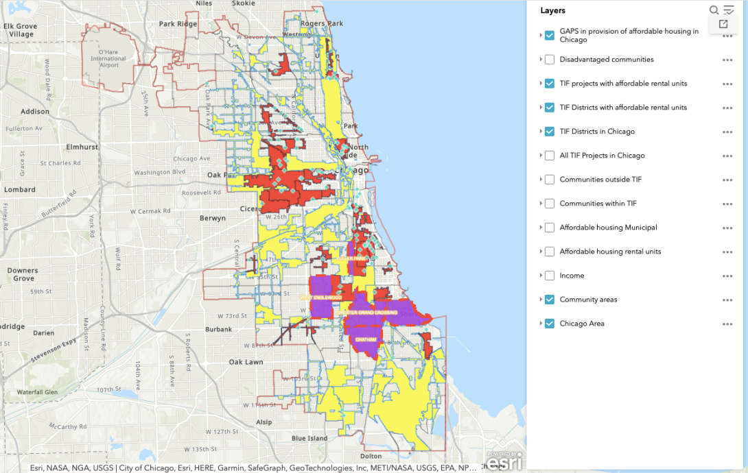
Authors: Ievgeniia Dulko and Gvantsa Nikolaishvili
According to the City of Chicago Department of housing officials, there are more than 120,000 affordable housing units short of what is needed. Chicago is trying to increase the affordable housing opportunities since 2007 when the first Affordable Housing Ordinance, known as the ARO, has passed. According to the data collected by The Center for Tax and Budget Accountability, in Chicago, both the city government and the Chicago Housing Authority work to provide rental housing priced below market rates and other housing subsidies. Each used a mix of subsidized developments and vouchers that households can use on the private market. Together, in 2017 they support just under 89,000 rental households. Although the Chicago Tribune investigation in 2018 revealed, that within ARO in many cases developers build the minimum requirement of affordable units and pay fees to the city not to build them all. Also, the fees paid by many developers to fund affordable housing have been mostly steered away from gentrifying neighborhoods. And even more, the majority of neighborhoods didn’t see this money invested back in affordable housing.
2. Evictions in Atlanta: A story of spatial segregation Heading link
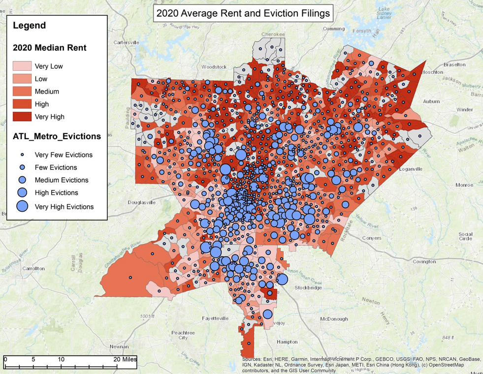
Authors: Madelyn Morgan and Philip Wasserburg
This project was inspired by a report from Housing Action Illinois that examined tax sale evictions in Cook County (Chicago, IL) and the racial disparities this process revealed. We wanted to look at evictions in Atlanta, another major US city known for its racial segregation. Since the Covid 19 pandemic brought evictions to the forefront of policy making decisions, through bills such as the CARES Act and the CDC Moratorium, we found ample data to look at from this time period.
3. Inventorying Chicago’s Rooftop Amenities in the Loop Heading link
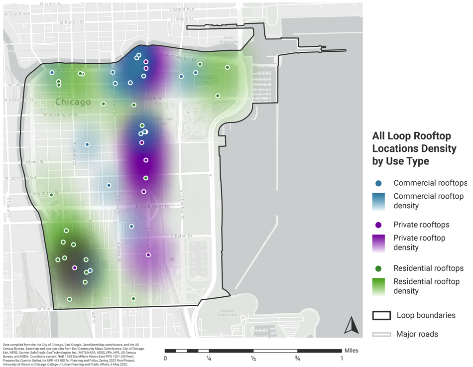
Author: Quentin Galliot
As Chicago continues to grow, both outwards and upwards, the development and redevelopment of buildings’ rooftops to implement amenities such as dining, entertainment, recreation, and more, has become increasingly more popular and widespread. However, despite the increase in this trend, there currently exists no comprehensive dataset or catalog of all of the rooftops across the city and their characteristics. Therefore, further analysis on how rooftops are affecting the city or being affected by the city is unable to take place, and the current understanding of Chicago’s rooftop life and nature is constrained and extremely limited by the unavailability of data on these locations for comparison. In an attempt to remedy this gap of available data, this project sought to create a detailed inventory of all of the rooftops in the Loop community area of downtown Chicago.
4. Behavioral Health and Green Spaces in Chicago, IL, USA Heading link
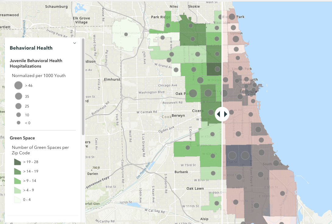
Authors: Wendy Avila, Zoë Harris, and Julia Liu
This project explores whether green spaces in Chicago are related to higher or lower rates of youth behavioral health hospitalizations. The two main objectives of this study are (1) to lay a foundation for youth behavioral health data for the city of Chicago and (2) to assess whether green spaces serve as a pro-mental health infrastructure. In Chicago, hospitals have reported a substantial increase in youth psychiatric services, and 44% percent of children experienced an increase in at least one mental or behavioral health symptom. Greenspaces play a pivotal role in population-level mental health and have been deemed an accessible and cost-effective intervention. They are linked to psychological relaxation and stress relief, social cohesion, and increased physical activity. Among youth, exposure to greenspaces is related to positive outcomes such as reduced stress, positive mood, less depressive symptoms, and better emotional well-being.
5. Chicago's Gentrification: How Chicago's communities are changing and the data behind it Heading link
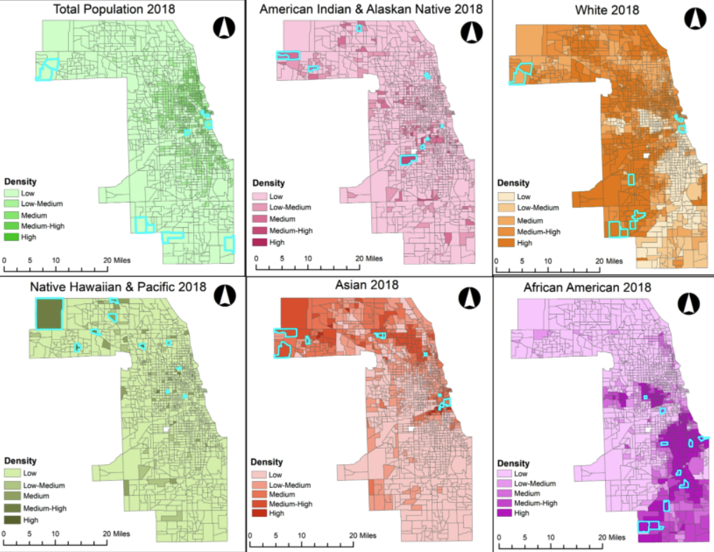
Author: Joe Perez, Josh Wieczorek, and Reis O’Donnell
In recent decades, many communities in the city have been experiencing changes in their household income, ethnic groups, and education levels. These adjustments amongst communities have caused displacements for minorities and low-income residents from the inner locations of Chicago. Our research for the gentrification of Chicago will compare the city’s demographics between locations from the years 2010 and 2018. The analysis of the spatial data from the years 2010 and 2018 will show hot and cold spots, which will be indicators of poverty, household income, education, and race shift over time. GIS will be used in this project for the purpose of organizing the large data sets collected and showing the displacements of communities over time.
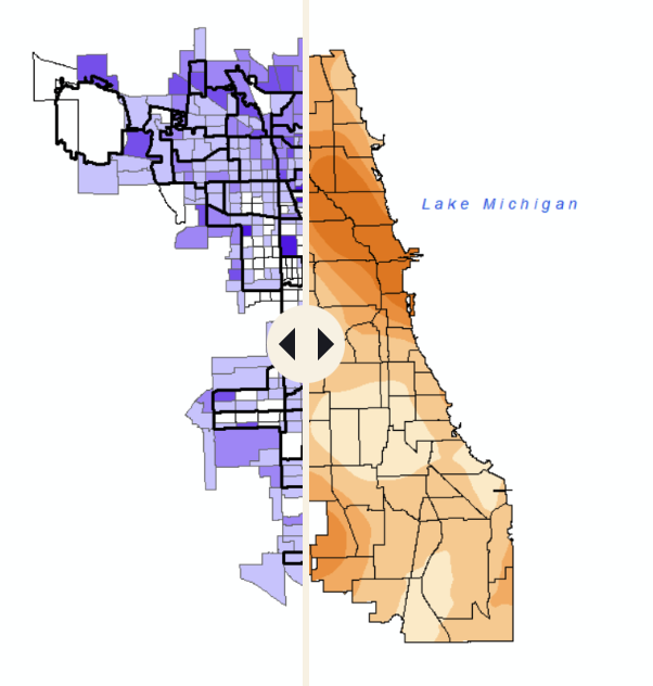
6. Flood Susceptibility of Public Housing in the Chicago Region Heading link
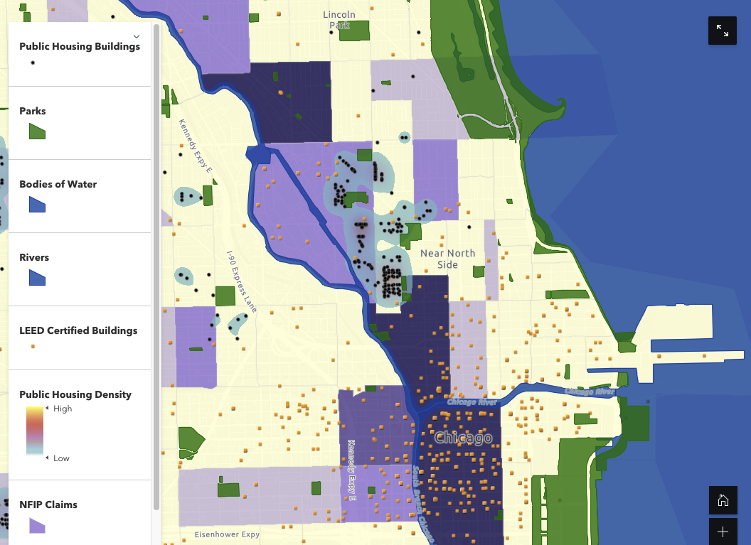
Author: Aspen Walters and Jocelyn Rodriguez
Flood resistant infrastructure is becoming more prevalent in cities around the world, but not at the rate cities need to combat flooding. Chicago, Illinois for instance, is in an especially vulnerable state. The city was built on top of a swamp, sitting right next to Lake Michigan. Our project will analyze the flood susceptibility of lower-income communities in Chicago. Chicago, IL is at a high risk of flood susceptibility. A majority of the land in the Chicago boundary shows the highest two levels of flood susceptibility.
Our project identified a high vulnerability in public housing concentration zones. Data concluded that despite income in the current day, these five neighborhoods which were previously minority concentrated communities, experience high levels of flood susceptibility. From our data, we’ve determined that the five biggest public housing development clusters in Chicago are (or were located in) disproportionately minority communities and are not adept for flooding. For instance, lack a sufficient amount of green spaces, green infrastructure, or permeable surfaces.
7. Business Density in Chicago Heading link
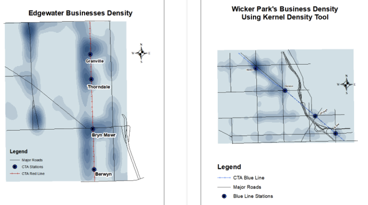
Author: Haley Deem, Karina Chavez, and Taha Doha
The purpose of this project was to analyze the trends in business density in Chicago neighborhoods where transit is present. We often see maps that show color trends of population density, income, or race, but never for business. Our group wanted to see the density of businesses visualized through GIS. Our goal would be to display the density through different tools like Spatial Join or Kernel Density. The proximity of stations often imply that more businesses will be around due to transit oriented developments, but also are aware of that trend not being as present in lower income communities. We decided to look specifically to the neighborhoods of West Town and Edgewater. Due to the limitations of this project, next steps would include the disparities between affluent neighborhoods with transit versus disinvested neighborhoods with transit.
8. Food Access, Transit & Health Outcomes: A comparison of two Chicago neighborhoods Heading link
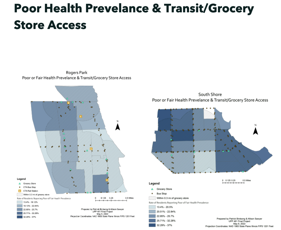
Author: Patrick Birdsong and Allison Sawyer
Eating well is a critical component of maintaining good health and preventing and reversing disease. But eating healthily is easier said than done. Food deserts — areas that have few, if any, grocery stores — persist in several Chicago neighborhoods. These food deserts are more likely to be found in racially segregated and low-income communities, particularly on the city’s South and West Side. 19% of people in the Chicago region are food insecure, despite increases in supermarket locations over the last decade, and 26.78% of Chicagoans do not have access to a car, making access to healthy food even more difficult. Ensuring a healthy and balanced diet can be difficult for residents who don’t have places to buy healthy food at a reasonable price, or do not have public transportation options that allow them to easily reach food destinations.
Our analysis aims to evaluate the relationship between access to grocery stores in Chicago and diet-related health outcomes. Through GIS methods and tools, we hope to understand the relationship between grocery store locations, transit access, and health outcomes within and between two Chicago neighborhoods.
9. Income Disparity Within Foreign Born Asian Indians, Chicago Heading link
Author: Nimisha Sharma
South Asians have been trapped under the notion of being a “model minority” whose voices go unheard. The immigration policy and its adverse outcomes go highly unnoticed, which is an issue as it creates a vast income disparity among the high and low skilled workers. Therefore, my research question was “Can Reforming Immigration Policy Lessen the Income Disparity among Chicago’s Indian population?” for my Urban Public Policy Fellowship. The visualization has been done to be able to make it easier to understand to address the relevance of the topic and bring out the importance of studying income disparity in this community.
10. Indicators of Crime in Chicago, Illinois. Segregation is Limiting non-White Chicago Residents, but in Way You Did Not Expect Heading link
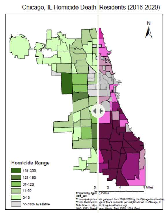
Author: Yulissa Aguilar
The purpose of this research is to study the relationship between race/ethnicity, education attainment, per capita income and the homicide rate in Chicago. An outcome of this investigation will be to understand if White and Black segregation from the 1970’s still have an influence today by reviewing attainment of a high school education, there is also review of per capita income. The study will also include a literature review to determine if these factors contribute to a high concentration of crime in largely Black populated neighborhoods.